Over the years, many people have commented on the existence of small streams or creeks scattered around Newmarket and have asked me where they originated. Let's look at the vast water network that still exists under our feet, beginning with a little pre-history of our area. For more on the Holland River and its specific place in our history, you can check out my article.
We are in what is called the Simcoe Watershed, which extends from the Oak Ridges Moraine north to Cooks Bay, the southernmost part of Lake Simcoe. The moraine is the source of four rivers, the Humber, the Don, the east branch of the Holland, and the Nen, now known as the Rouge. We'll focus on the east Holland River, which travels northeast to Cooks Bay.
If you drew a line from Holland Landing southeasterly to the mouth of the Rouge River, then along the shore of Lake Ontario west to the Humber and then back north to Holland Landing, that wedge would represent a uniquely historic region of Upper Canada. It contains three trails that all come together at Holland Landing, the Humber, the Don, and the Rouge. These trails were our early highways, connecting Lake Ontario with the lands that lie beyond Lake Simcoe, a vast uncharted wilderness known by the Indigenous name, Toronteau.
At one time this name was applied to all the area between Lake Ontario and Georgian Bay. This region was inhabited by our Indigenous ancestors, who knew of and utilized this incredible water network for centuries before our arrival.
Early maps indicated a water route north and at the end of 12 leagues is the river Escoyondy, the Holland River, which runs northeast about 10 leagues and falls into Lake Toronteau (Simcoe), according to Agustus Jones, Simcoe’s official engineer.
Dr. Percy Robinson, in his book Toronto and the French Regime, wrote extensively about our branch of the Toronto Carrying Place and observes that the trail probably passed close to the fortified village east of Vandorf, and from that point passed to the east of Newmarket and onto Holland Landing.
This extensive water system provided them with a strategic position from which to control the valuable fur trade across the carrying place from Lake Simcoe. This, in turn, had an important bearing on the beginning of Newmarket, providing the settlers with the easiest way into the back country.
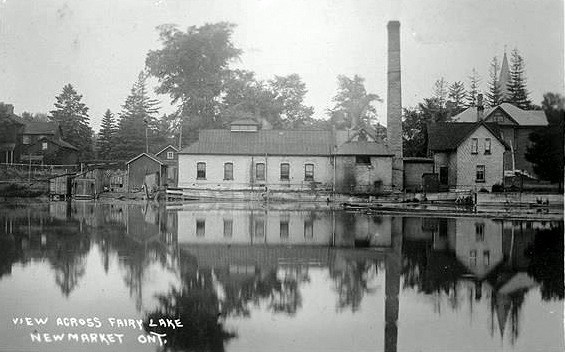
In the early history of the area, the East Holland River provided an important source of water for agriculture, irrigation and mill operations. In the 1800s, the river supported several mills and prior to that provided fish and other food for the Indigenous peoples.
In earlier articles on the challenges that fire and water-borne disease presented to our town, and the need for a readily available source of water and the eventual development of the waterworks system that would change everything.
The development of the waterworks system is of interest to us as the source of this water was the discovery of several artesian wells throughout the town that fed the system. A report published in the North York Reformer in 1876 speaks of “five new tanks, each a capacity of 4,800 gallons, had just been put down, bringing the total to seventeen wells, along with a creek in the east, one west of Garbutt Hill, and the mill pond (Fairy Lake).
Diseases, including typhoid fever, diphtheria, cholera, and smallpox, were all borne by water. Most people were on private wells, and it was evident that Newmarket was part of a closed water system. Animals roamed at will and the filth of pig pens and chicken pens infested with rodents existed in local backyards. The forest trees and the swamp had been cleared and open streams had become sluggish, open sewers.
A test well was sunk in August 1887 and Newmarket’s first well struck water at 140 feet. It would flow at the rate of 1 1/4 gallons per minute. It was determined that the steam power and pump house would be situated in the vicinity of the artesian wells at the south end of Main Street, west of the bridge at Fairy Lake. A reservoir was created by the end of October 1888 and house service was begun soon after.
The result of the new domestic water system brought about two changes immediately. There was a sharp decline in the cases of water-borne disease, especially typhoid fever, and with the adoption of artesian wells and the domestic service, the Fire Underwriters’ Association, raised our rating from Class D to Class C. The waterworks map of 1915 I have provided reflects the total expanse of this new system.
A new reservoir composed of a circular foundation 16 feet deep, 60 feet in diameter, a stone wall 2-1/2 feet high and a capacity of 160,000 gallons and was built seven feet above ground on a 14-foot slope was added on Garbitt Hill (Prospect and Timothy Street) the next year.
This reservoir would be filled twice daily by pumping from the 30,000-gallon reservoir at the waterworks, into which all the wells flowed. This ‘reservoir on the hill’ would produce a constant pressure of forty pounds per square inch into the mains.
Two more wells were drilled to a depth of 250 feet, as it was discovered that the flow was from the 150-foot mark.
Additional wells were sunk that provided about 42,000 gallons every 24 hours. These first artesian wells were within a short distance of each other along the railway tracks near Fairy Lake and were pumped by air lift.
The main well would experience some difficulties over the years, filling up with mud, but after a few weeks it would clear and soon it was producing 200,000 gallons of crystal-clear water, evidently spring water being filtered through a bed of gravel which we knew blanketed the area.
I have provided an interesting photograph of a well on Water Street as part of this article.
By spring 1894, our system of fire protection and water supply was composed of the following plant: A powerhouse containing a large boiler on which steam was kept constantly at 40 pounds, attached to a pair of large pumps connected with the lower reservoir, 16 by 18 feet, into which flows 1,500,000 gallons daily from five artesian wells which are from 150 to 266 feet deep. The pump house still sits behind the old hydro building.
The events recorded above were all taken from contemporary local newspapers, the Newmarket Era and from some minutes of Newmarket council. The maps provided are from the George Luesby archives.
When you think about it, a minor miracle takes place each time someone in Newmarket turns on a tap and crystal-clear water gushes from this extensive underground waterway. Geologists maintain that a connecting waterway between Georgian Bay and Lake Ontario exists and that the Laurentian River was never completely blocked when the last of the glaciers melted. Instead, it was filled with loose material, mainly boulders and sand, which provides seepage.
It is believed that the deep wells that were bored penetrated this ancient riverbed, though tests in the Newmarket area indicate that the centre of this valley lies slightly to the west and that the flow is from east to west.
As I indicated above, the main river in Newmarket is the East Holland River, and all other streams in the town are tributaries of this river. This includes Bogart Creek, a brook that weaves its way into the town from the Oak Ridges Moraine by way of Bogarttown, emptying into the Holland River in north-central Newmarket; the Western creek, another brook rising just west of the town, and reaching the Holland River in the town's north end; Tannery Creek, a stream that joins the Holland River in south Newmarket after flowing through Aurora; and a number of other small watercourses.
Today there are two reservoirs in Newmarket; at Fairy Lake, managed by the Lake Simcoe Region Conservation Authority, which is a former mill pond on the East Holland River; and the Bogart Pond, also a former mill pond, fed and drained by Bogart Creek in Bogarttown.
Newmarket also lies south of and above the ancient Algonquin Shoreline, where elevations suddenly drop off from the gently rolling hills that characterize much of Newmarket to the much flatter, lower land down below in the Holland Marsh area.
Geologists tell us our area is characterized mainly by glacial deposits from the last Ice Age, known as the Newmarket till. The town sits mainly on a sand and gravel base, ground by the ice sheets that covered the area until about 10,000 years ago. There are no outcrops to be found anywhere in Newmarket given the depth of the glacial deposits.
Since I am not a geologist, I have drawn on expert accounts on the subject from government agencies such as Geology Ontario and Geology and Geoscience.
We as humans tend to believe that we can control nature, that we can redirect rivers and streams and, in many instances, just build over them. Then an event like Hurricane Hazel, in the fall of 1954, occurs and all our efforts are swept away by a torrent of nature.
We create artificial water facilities like stormwater ponds or irrigation ponds, capturing the water that is just under the surface. This water then finds a way up to the surface unexpectedly and you encounter it in your neighbourhoods or backyards.
I will end this account with a funny personal story. I worked for two summers at Newmarket Cemetery digging graves. It always amazed me that within a few minutes of digging the graves they would begin filling up with water. The cemetery being located on a hill, I was confused given my understanding of physics and the elevation until I realized that the cemetery sits on an artesian well.
Additional sources: The History of The Town of Newmarket by Ethel Trewhella
Newmarket resident Richard MacLeod, the History Hound, has been a local historian for more than 40 years. He writes a weekly feature about our town's history in partnership with Newmarket Today, conducts heritage lectures and walking tours of local interest, and leads local oral history interviews.


