Let’s return to the story of the development of our area before the arrival of our earliest settlers and the story of the Indigenous peoples who lived in our area.
As early as 1785, Chevalier de Rocheblave had drawn attention to this new trade route north through our area, urging its advantages. Negotiations began through Sir John Johnson, the Indian agent, with the Mississaugas to purchase the land lying on both sides of this western trail. A survey of land along the north shore of Lake Ontario and any parts of the country on both sides of the route from Lake Tarento to Lake Huron was arranged.
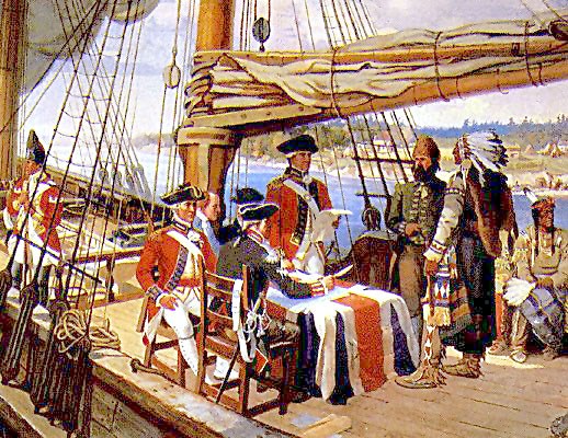
On Sept. 23, 1787, the government party met the band of Mississaugas at the head of the Bay of Quinte. Sir John laid his map showing the desired tract of land from Lake Tarento to Lake Huron, before the Indigenous people. They agreed to grant this tract, and the Deed of Gift was signed by affixing the Chiefs’ emblems or figures of their respective totems. Did they intend to sell the land to the government – unlikely?
An examination of the map shows the purchase consisted of two parcels of land that constituted the land links between Lake Ontario and Lake Huron and were connected by the waters of the Holland River and Lake Simcoe. The land was purchased primarily for the use of the fur traders in Montreal.
The southern block of this purchase measured 14 miles by 28 miles and extended almost up to the town of Aurora, including much of the western part of York County and city of Toronto. It is called the Toronto Purchase from the original Portage de Toronto, the route between Lake Ontario and Lake Huron via the Humber to Lake Simcoe and the Matchedash and Georgian Bay.
On Aug. 14, 1791, the British government passed the Constitutional Act, dividing the colony into Upper and Lower Canada and then in 1792, John Graves Simcoe, the first lieutenant-governor of Upper Canada, he issued his Proclamation of the Division of Upper Canada into 19 counties of which York was the fourteenth.
He was interested in a spot at the mouth of the Don River on the shores of Lake Ontario where the French Fort Rouille of 1750 had stood, a good military and commercial base attracting the Indigenous peoples from the north shore of Lake Huron who were currently carrying their furs westward to Michilimackinac.
The fur trade had lost interest in the shortened north route from Lake Huron, but Governor Simcoe viewed the Toronto Purchase favourably and decided to proceed.
On Sept. 25, 1793, Simcoe set out on horseback to explore the western route for himself. Returning Oct. 11, they are said to have camped for the night on the eastern branch of the Holland River, only to discover they were following yet another trail, known as the Ellerby Road that led directly to the Don River.
Simcoe, seeing the military advantage, decided this shorter route better suited him. This trail was known only by a few of the Indigenous peoples, an easy portage between York and the waters about 30 miles away.
On Feb. 26, 1794, Augustus Jones was instructed to begin a survey of the Don Trail and by March 1794 it was completed to Holland Landing. Simcoe named the new road Yonge Street in honour of Sir George Yonge, minister of war; Lake la Claies was renamed Simcoe in honour of his father, and the river was to be called the Holland for Major-General Samuel Holland. Major Holland had been with General Wolfe at Quebec.
When Governor Simcoe was told of the 1787 purchase of land from the Mississaugas and their subsequent protest regarding the sale of their lands, he wanted to see the actual deed covering the Toronto-Matchedash Purchase. The deed was missing.
The Indigenous peoples were greatly dissatisfied over the sale of their lands. There was a fear of possible raids. Adding to this, an Indigenous chief had been murdered and his murderer had not been brought to justice. So serious was the fear of an Indigenous uprising that the settlers on lower Yonge Street permitted any wandering Indigenous peoples to pass freely on their lands.
In 1794, the treaty for the land from Lake Ontario to Lake Huron was discovered, a blank deed attached to it. The document did not bear the signature of Sir John Johnson, and none of the boundaries of the territories defined. The blank deed was drawn in such a way that it might apply to any lands in Upper Canada held by the Mississaugas. The whole document was so carelessly executed that it was deemed invalid.
In 1798, it was decided to summon all the chiefs interested in those tracts and inform them that a correct plan or survey of the disputed area had been done according to the boundaries mentioned in each purchase.
Further, they were asked to sign the new agreement and return it at the next distribution of presents. They saw the question settled. This may explain the delay as this second meeting did not take place until seven years after the original signing, on Aug. 14, 1805 on the banks of the Credit River. On this occasion, the interested chiefs were present, and the transfer of land was confirmed, and the date of the Toronto Purchase was ratified by the letter of Sir John Johnson.
The negotiators pleaded for the rights of these Indigenous peoples, noting the pitiful situation of the Mississaugas and recommending a further sum be stipulated in the provisional agreement.
Another problem arose with the agreement as the Don Trail was preferred to the Humber Trail as the link between Lake Ontario and Lake Huron. The new road from just below Aurora (Yonge Street), lay outside the land purchased from the Indigenous peoples and a protest ensued.
The obscurity of the 1787 deal, and the missing deed, created an uncertainty of the legal tenure of the land and north Yonge Street remained unoccupied until 1801 when Timothy Rogers brought in the Quaker settlers from the United States.
The area immediately north of the 1787-1805 surrender was covered by the Treaty of Oct. 17, 1818, which completed the total surrender of the territory from Lake Ontario to Georgian Bay and was the most extensive of all.
Four Chiefs of the Ojibway (Chippewa) nation took part in the negotiations, the Musquakie (Yellowhead), Kaqueticum (Swamp), Manitonobe (Male Devil). The chiefs were promised a yearly sum of 1,200 pounds, granted a tract of land whose eastern boundary extended from the south shore of Kempenfelt Bay, along the western shore of Lake Simcoe and Cook’s Bay, and the Holland River to the northwest angle of the Township of King. The lands of East Gwillimbury were apparently never formally ceded by the Indians until 1923.
The definite date of the transfer (of payment) of treaty money and presents to the Indigenous peoples from the Credit River to Holland Landing has never been verified, but Peter Jones in his diary of 1827 refers to a payment made at Holland Landing.
In May 1829, Sir J. Kempt recommended that the Indigenous peoples be collected and placed on reserves. So much for dealing in good faith.
Sources: History of Scarborough Township by Doyle; The History of Newmarket by Ethel Trewhella; The Atlas of the County of York, 1878; Chevalier de Rocheblave and the Toronto Purchase, by Doctor Percy Robinson; The Newmarket Era; Indian Department Papers courtesy of National Archives, Ottawa
*************
NewmarketToday.ca brings you this weekly feature about our town's history in partnership with Richard MacLeod, the History Hound, a local historian for more than 40 years. He conducts heritage lectures and walking tours of local interest, as well as leads local oral history interviews. You can contact the History Hound at [email protected].
