Let’s look back at the time before many of our ancestors arrived in 1801. In this first of a two-part series, I’ll focus on the Indigenous in this area pre-1799.
The opening of the region north of the Oak Ridges Moraine, the elevated area between Lake Ontario and Lake Simcoe, in large part occurred because of the American Revolution. However, more than 100 years of events had taken place before that.
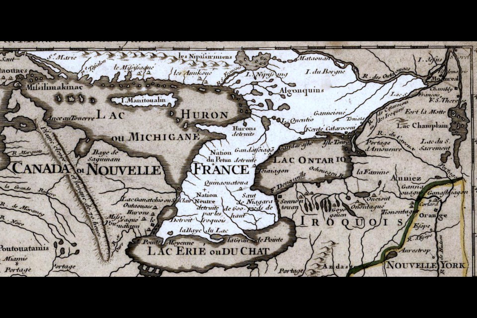
The Oak Ridges Moraine gives rise to four rivers: the Humber, the Don, the east branch of the Holland, and the Nen, now known as the Rouge. The Humber and Don wander south to Lake Ontario, the east Holland starts on its way to Lake Simcoe and the Rouge, fed by several small lakes, makes its way southeast to Lake Ontario. Its persistent current had pierced a hill of red tenacious clay that sufficiently coloured its waters to justify the name Rivière de Rouge. Significantly, it is the Rouge today and the name is the only record of an old Sulpician Mission established here in 1669 during Louis the XIV’s rule.
If we were to draw a line from Holland Landing southeast to the mouth of the Rouge River, along the shore of Lake Ontario west to the Humber and back north to Holland Landing, that wedge of land encloses a uniquely historic region of Upper Canada. It contained three trails all coming together at Holland Landing: the Humber, Don and Rouge.
These trails were not just paths through the forest; they were the highways, the Carrying Places, which connected Lake Ontario with the lands lying beyond Lake Simcoe, that vast uncharted wilderness known by the Indian name Toronteau.
At one time this applied to all the area between Lake Ontario and Georgian Bay. It was Champlain who brought the three lakes, Huron, Simcoe and Ontario, to the attention of Europeans, and it was here on the northern part of this Carrying Place that one of the first, if not the first, Christian Missions was established in Upper Canada.
This region was thickly inhabited by our Indigenous people, and was a meeting place for numerous tribes. Our history books tell us it was from these inhabitants, over time, all land in Upper Canada was purchased.
If we examine early maps and accounts of the Rouge portage area, we find descriptions of an area stretching 52 miles from Quinte (Carrying Place) to the River Canetiagon (Rouge). At the mouth of the river, there was an Iroquois village. The river is described as navigable for two leagues; at the end, there is a portage of 41 miles through good country of low hills.
The route is northerly and at the end of 41 miles is the River Escoyondy (Holland). The river runs northeast about 35 miles and falls into Lake Toronteau (Simcoe). This is an early reference to the Rouge Trail. I have converted distances to miles, but it must be remembered that the length of the league (which is quoted in the documentation) varied from century to century, as did the length of the mile.
We don’t have the surveyors’ notes or diaries of day to day progress available to accurately establish the Humber and Don Trails. With the topography having been altered over the years by agriculture and the difficulty of computing distance through bush country, the specific windings remain obscure, although a careful search of records and maps has been undertaken by historians.
Historians have differed in their interpretations of the Rouge Trail route. Dr. Percy Robinson, in his book Toronto and the French Regime, has written at length of this branch of the Toronto Carrying Place, and observes that Joliette’s map and Raffeix’s map seem to indicate the trail did not follow the valley of the Rouge but ran in a northerly direction toward Stouffville, along the watershed to the end of the little Rouge. If so, the trail probably passed close to the fortified village east of Vandorf, so well-known to archeologists, and from that point passed to the east of Newmarket and on to Holland Landing. Therein lies the conundrum for our accepted accounts.
While a prominence is given to the Humber Trail by recent historians, maps previous to those of LaSalle indicate that the eastern trail rivalled in importance the western branch of the Carrying Place and was the route usually followed.
When I attended university, they told us it was the Rouge that attracted the attention of the explorers and usually appeared on their maps, but most give few details that are of help in determining its course. Like the Humber Trail, it probably had more than one starting point and termination.
It must be remembered that these trails had alternate routes and many branches. We do know that the Rouge flowed deep and broad for five miles. The trail, though a little longer than its western counterpart, then angled across easier country in the direction of the Holland River and Lake Simcoe.
In school we learned the story of how, during the French regime, the beaver was becoming scarce south of Lake Ontario, and the Iroquois, by extermination of the Hurons, controlled this extensive northern territory and used the Rouge Trail as a main highway in their trade.
The Jesuit Fathers spoke of the trail as being “unfrequented” or “impossible to use”. Then in 1666, the French made an uneasy peace with the Iroquois and were able to ascend the St. Lawrence River and the Rouge Trail became reasonably safe for the Indigenous, explorers, missionaries, trappers and traders.
By this trail, in 1669, Louis Joliette and Sieur Pere were the first white men to have passed this way after the expulsion of the Hurons. By 1700, the Iroquois had either withdrawn or been expelled from the north shore of Lake Ontario and the Mississaugas established.
Their villages were permanent because of the abundance of game and salmon, and abandoned only by deterioration of sanitation. They extended along the lakeshore from Kingston to Niagara, the most important being Ganatsekwyagon near the mouth of the Rouge, and Teiaigon near the Humber. These were strategic positions that permitted them to control the valuable fur trade across the Carrying Place from Lake Simcoe.
These trails had an important bearing on the beginning of Newmarket. For the settlers, they provided the easiest way into the back country. Following the conquest of Canada by the British in 1763, the fur trade, the background against which settlement is generally set, was established and controlled by a powerful group of Scottish and French merchants.
In 1774, they developed into the North West Trading Company with headquarters in Montreal. These doughty traders dominated the government and considered the natural riches of the land to be exclusively theirs.
To offset the tremendous competition felt by the traders, they began to look for a shorter route than the one by the Ottawa River to Montreal, and they focused their attention on developing the western branch of the Toronto Carrying Place, the Humber Trail, from Matchedash (Severn) on Lake Huron to Lake Ontario.
Next week, we will take up the story of the push north along the Rouge / Holland Trails into our area and the consequences for both our early settlers and local Indigenous population.
Sources: The History of Newmarket by Ethel Trewhella; Chevalier de Rocheblave and the Toronto Purchase by Dr. Percy Robinson; The Newmarket Era; Toronto Past and Present Until 1882 by C. Pelham Mulvany.


