This topic is one that resonates both from our historic past and the events currently before us — the Bradford Bypass extension.
I hope to show a knowledge of our past can quite often benefit us when it comes to current issues.
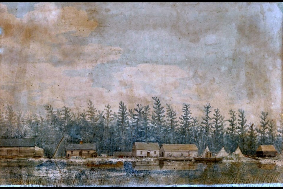
One of the first major export industries in our area was the fur trade. History tells us of a North West Company fortress that once stood on the Holland River in what is now Holland Landing. There is certainly no doubt Pine Fort did, in fact, exist as there are so many references to it in various historic and personal memories. However, its exact location remains a puzzle to historians.
In earlier columns in this series, I have spoken of the local entrepreneurs who laboured in the fur trade and established Pine Fort as their office, if you will. The Chippewa would gather at the fort in Holland Landing to trade their furs and receive their various payments from the government land deals. The fort appears in early schematics of the Yonge Street route, with York (Toronto) on the south end and Pine Fort on the north.
The description left behind for us is of an enclosed bastion of locally sourced pine logs, which formed a defensive structure built by the North West Company, a well-known landmark for the various explorers and fur traders who travelled the Rouge River north and then portaged through our area on their way to Huronia and Canada’s great northwest.
Accounts from locals William Roe, Andrew Borland and Elisha Beman tell the story of how the Indigenous peoples travelled south through the Great Lakes system to ‘the Landing’ to trade their furs and conduct their affairs with these newcomers to the south.
An old survey of the Holland River shows a fort at the entrance to what became known as Lake Simcoe. History speaks of a fort located seven miles and 52 chains from the entrance of the Holland River to Lake Simcoe. The shoreline of the lake has receded over the years, and one has been able to accurately calculate the actual location of the fort. While the location was common knowledge for much of our early history, sadly, its exact location seems to elude us today.
With the prospect of the Bradford Bypass, there is a renewed push to find the fort, and if it is, as surmised, lying in the road’s path, it would be nice to discover it. Once the road is built, it will be too late to find out we paved it over.
In Augustus Jones’s July 24, 1795 report to John Graves Simcoe, he reported Yonge Street was now open from York (Toronto) to Pine Fort Landing (Holland Landing) on Lake Simcoe.
Dr. Scadding, an early Toronto historian, reported having visited the fort on his various visits to the Landing, and he documents the interactions of the Indigenous peoples with the new local white settlers. He confirms the trading of furs from the peoples to the north, who had arrived by canoe and portage via the Lake Simcoe route, and the existence of a payment station that was located within the fort structure. An added detail he reports is the Holland River at the junction with the fort was about 25 yards in width.
On its own, the idea that one of Canada’s earliest structures and earliest fur trading post lies undiscovered, waiting for its rediscovery, excites my historical curiosity, and perhaps the Bradford Bypass and the studies that have ensued surrounding its future may yet unveil a long-lost local historic treasure.
It may be prudent at this point to examine the connection between the issue of the Bradford Bypass and the renewed interest in finding Pine Fort and, if necessary, protecting it from development.
The Lower Landing, one of the top historic sites in Canada, is located on Lot 118, on the west side of Yonge Street. I have written several columns set in this historic area.
According to FROGS, an East Gwillimbury association’s informational blog, Canadian Heritage Landscapes (CHL) applied in 1997 to the Historic Sites and Monuments Board of Canada, requesting the Lower Landing be designated a National Historic Site and the associated cultural landscape be protected from any intrusion by the proposed Bradford Bypass.
The board would request more archeological evidence that the site identified by CHL was indeed the Lower Landing and more collaborating evidence of the historical activities that are said to have occurred on the site. There is some historical confusion relating to the various historical accounts that treat the Lower Landing, the Upper Landing (located about two-and-a-half kilometres upstream) and Holland Landing as all the same location.
We know the Lower Landing was the northern terminus of the Carrying Place Trail and served as an encampment and embarkation site for the First Nations peoples. Historical sources fix the location as where the annual payments made by the British to the Chippewas as part of treaties known as the Upper Canada land surrenders — treaties that ultimately evolved into the 1923 Williams Treaty — took place.
We know Gov. Simcoe passed through the area in 1793, establishing his route from York (Toronto) to the Holland River, terminating at Lot 118.
This area represented the end of the stagecoach line north from York (Toronto). We all know the story of the Holland Landing Anchor and that the site was a hub of military activity during the War of 1812.
It also served as the docks and landing point for the steamboats used on Lake Simcoe in the 1800s and the route taken by our major explorers, fur traders, soldiers and settlers, and served as a major route to and from the upper and lower Great Lakes and between Eastern and Western Canada for several hundred years.
In 1997, a two-phase archeological assessment was conducted of a portion of the proposed route near the east branch of the Holland River, producing an archeological site designated BaGv-42.
Then, in 2006, a Stage 3 archeological assessment of BaGv-42 added to our understanding of the nature of activities attributed to the Lower Landing. It raised some concern the East Holland River site contained the remains of the early-19th-century Lower Landing site as creamware and pearlware shards were recovered from East Holland River, dated to about this period, along with an English trade axe. However, no trade beads or trade silver have been recovered, nor was any evidence of the historic Indigenous camp, which was reportedly associated with the Lower Landing site.
In the historic information compiled by Nancy Eves Robinson in The History of Holland Landing, it is suggested the Lower Landing site may be located farther south along the river. The Lower Landing located at the East Holland River site can only be determined if the site is further excavated.
This assessment prompted other parties to step forward, namely the Chippewas of Georgina Island, who are on record indicating they want this site left untouched forever, stating the site was critical and instrumental to the formation of Canada and one of the contributing factors to our people to take up a permanent settlement on Lake Simcoe’s south shore.
While these grounds have only undergone preliminary excavation, it does appear they have been used for more than 1,000 years. If so, the value of this area cannot be underestimated.
It would be a shame to see a significant piece of our history lost forever. This area was home to all of our forefathers, European and Indigenous, and for the Indigenous peoples, given the length of time this site was occupied, there will undoubtedly be burial grounds in this area.
Understandably, they fear people may dig up this site, creating a tourist attraction, and they advocate for the area to remain undisturbed.
The establishment of the Bradford Bypass initiative has certainly prompted researchers to ‘place their foot on the gas’ regarding their efforts.
A deed registered Jan. 24, 1914, title of the waterfront portions of lots 117 and 118, passed to His Majesty King Edward VII, probably part of an expropriation for the planned but eventually abandoned canal. Attached is a survey showing the location of the Lower Landing, just south of BaGv-42, which would seem to establish the Lower Landing is not located about two-and-a-half kilometres south of the highway route as reported.
This whole saga is presented to demonstrate current events often serve as an impetus to re-examine historical mysteries and to reconsider our past given a current threat.
Various historical and environmental groups have continued to push for more information and for a renewed investigation of the significance of this issue.
For my part, I only hope all of this results in a better understanding of our local history and a renewed focus on solving those historical mysteries that still confound us today.
Hope to see everyone back here next week.
Sources: Stories of Newmarket: An Old Ontario Town by Robert Terence Carter; Newmarket Era articles; oral history Interviews conducted by Richard MacLeod; columns published on NewmarketToday, Remember This by Richard MacLeod; The History of Newmarket by Ethel Trewhella; The Yonge Street Story 1793-1860 by F.R. Berchem; FROGS, an East Gwillimbury association’s informational online blog; The History of Holland Landing by Nancy Eves Robinson; Early Fort Stood on Holland River by Terry Carter; watercolour of the Naval Depot at Holland Landing by Robert Irvine, Royal Ontario Museum.
Newmarket resident Richard MacLeod, the History Hound, has been a local historian for more than 40 years. He writes a weekly feature about our town’s history in partnership with NewmarketToday, conducts heritage lectures and walking tours of local interest, and leads local oral history interviews.


